Monday, January 25, 2010
Juan's project for featured-oriented synchro is on OW2Forge
OW2Forge give news on Tellus project (Juan's project part ) on : http://forge.ow2.org/forum/forum.php?forum_id=1764 for the featured-oriented synchronization.
Saturday, January 23, 2010
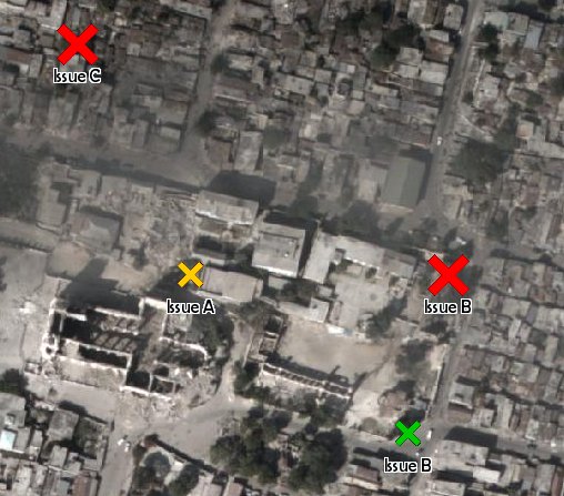
Haiti
The situation in Haiti is an example where synchronization of POIs is a good option:
This is what the surveyor does:

This is what the WMS client shows:

Server:
http://hypercube.telascience.org/cgi-bin/mapserv?map=/geo/haiti/mapfiles/4326.map
I think layer is correctly georeferenced:
noaa-01-18-4326
- As soon as a surveyor reaches an internet-enabled spot, new POIs are added to the database and WMS clients (for example in a coordination office) can see the changes instantly.
- As new POIs from surveyors A, B, and C get into D's handheld, D knows which areas need more attention and needs not update large amounts of raster data, since each point feature needs only a few bytes to be transmitted.
This is what the surveyor does:

This is what the WMS client shows:
Server:
http://hypercube.telascience.org/cgi-bin/mapserv?map=/geo/haiti/mapfiles/4326.map
I think layer is correctly georeferenced:
noaa-01-18-4326
Subscribe to:
Comments (Atom)
